


Reports | 13 01 2026
 Mohammad al Haj
The Syrian Arab Army’s Operations Command announced, Tuesday, parts of the Deir Hafer area and the Maskanah subdistrict in eastern Aleppo governorate as a closed military zone, without any indication of opening safe corridors for civilians.
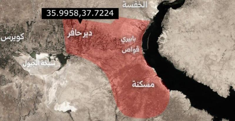
A statement published by the SANA news agency said that the area marked in red on the attached map in Deir Hafer and Maskanah is considered a closed military zone effective immediately.
The “Operations Command” confirmed that the reason for this was “the continued mobilisation of SDF units along with PKK terrorist militias and remnants of the former regime in this area, in addition to it being a launch point for Iranian suicide drones that targeted the city of Aleppo.”
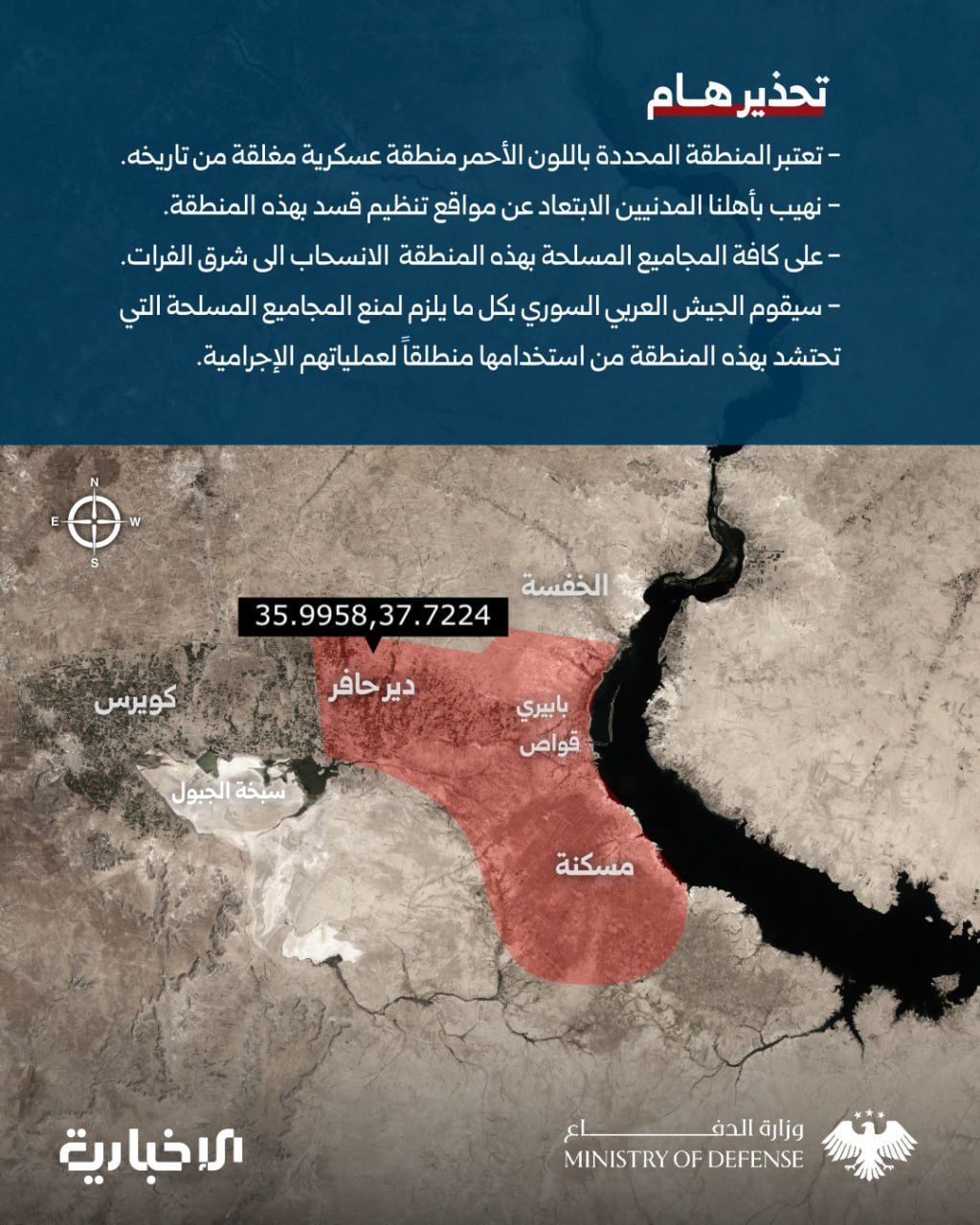
Map of the military zone announced by the "Army Operations Room" in Syria – Syrian News
Deir Hafer and Maskanah: No Corridors for Civilians!
Up to the moment of publishing this article, neither the Ministry of Defence nor the “Army Operations Command” announced any humanitarian safe corridors for the tens of thousands of civilians in the area, content only with the phrase: “We urge our civilian people to stay away from the positions of the SDF organisation in this area.”
Such general and imprecise maps can stir panic among civilians, due to the absence of detailed boundaries and precise points.
Under international humanitarian law, humanitarian or safe corridors are defined as “agreements between parties to an armed conflict that allow safe passage for a limited time through a specific geographic area. These corridors can allow civilians to leave, humanitarian aid to enter, or the evacuation of wounded, sick, or dead persons.”
Article 57 of international humanitarian law concerning “precautions in attack” stipulates that constant care must be taken to avoid, and in any case minimise, harm to the civilian population and civilian objects.
It requires those planning or deciding on an attack to take all feasible precautions to avoid or in any event minimise incidental loss of civilian life.
Article 57 emphasises that “effective advance warning must be given of attacks which may affect the civilian population, unless circumstances do not permit.”
Forces of the Aggression Deterrence Operation in eastern Aleppo countryside – Rozana
A Military Zone in Deir Hafer… Without Coordinates!
Any details about the map attached to the “Operations Command” statement are absent, beyond the names Deir Hafer, Maskanah, Babiri, and Qawas, and the indication of a single point with latitude and longitude.
When inserting the coordinates (35.9958, 37.7224) shown on the Command’s map into Google Maps, it reveals a location east of Sabkhat al-Jabbul near Deir Hafer, but it is not included in the red area.
The Ministry of Defence has not published any additional details about the coordinates in the military zone as of the time of publishing.
Unofficial estimates, based on the 2004 census, indicate that the population of the Deir Hafer area and Maskanah subdistrict is about 150,000 civilians.
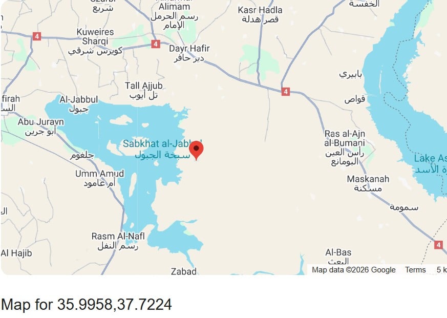
Location of the coordinate point on the military zone map in Deir Hafer – Google Maps
A Vast Map… Without Village Names!
According to open sources, the Deir Hafer area includes three subdistricts: Deir Hafer centre, Rasm Harmel, and Eastern Kuweires, encompassing more than fifty towns and villages, plus around 40 towns and villages belonging to the Maskanah subdistrict in the Manbij area.
Despite the use of specialised tools to calculate the area, the precise coordinates on the map and the villages and towns covered by the declared military zone remain inaccurately defined.
Based on estimates, the declared military area in eastern Aleppo covers about 508 square kilometres.
The Ministry of Defence’s map did not show any clarification of the other villages and towns included in the announcement, which overlap between areas under government control and areas controlled by the SDF.
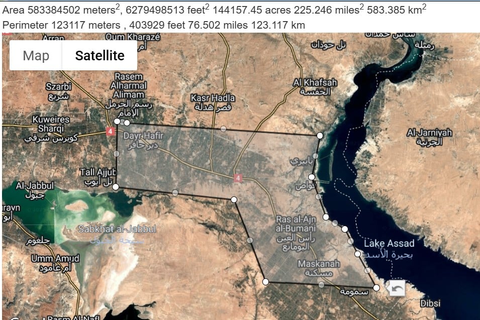
Approximate map of the military zone announced by the "Army Operations Room" in Syria – Mapdevelopers (Edited: Rozana)
After the Military Zone Announcement
The Syrian state news outlet said, after announcing the military zone, that a civilian was killed by a sniper from the SDF while attempting to leave Deir Hafer on a motorcycle.
The Manbij area announced the suspension of schools in the town of al-Khafsah and nearby schools due to their proximity to the military zone.
For the second time within days, the “Army Operations Command” has used the policy of announcing coordinates for targeted areas, having previously published several maps for specific buildings or confined areas in the Sheikh Maqsoud and Ashrafiyeh neighbourhoods — including two safe passage routes for civilians with specified usage times.
In the March 10 agreement signed between Syria’s interim President Ahmad al-Sharaa and the SDF commander Mazloum Abdi, Article 3 stipulates “a ceasefire throughout all Syrian territories.”
The latest escalation follows the exchange of statements between the two sides about military mobilisations in Deir Hafer, amid signs from observers of the possibility that government forces might control all areas west of the Euphrates after fully capturing the city of Aleppo following the Sheikh Maqsoud and Ashrafiyeh operation.